Start Of Spring Doesn't Mean End Of Winter In 2014
BALTIMORE (WJZ) -- Could we be in for more snow next week? It's a possibility.
Meteorologist Chelsea Ingram breaks down the details.
Timeline:
The models are trending more into agreement that central Maryland will not be in the path of a major early spring snowstorm next week. With that in mind, we think that it is still too early to rule out the possibility of accumulating snowfall and strong winds even though latest model runs are keeping the worst of the storm offshore.
Accumulations:
In order for the mid-Atlantic to see a "powerhouse storm" next week, we will need a few pieces of the puzzle to come together at the right time. One being the surface area of low pressure which will take shape most likely off the coast of Georgia. Another is a northern branch wave of energy that will spawn an area of surface low pressure in the near the eastern Great Lakes or upper Ohio Valley. Once these features combine, the storm will really get cranking later Tuesday/Tuesday night. If that happens far enough south and west, then we could be looking at accumulating snow. If it happens farther east, then not so much. Given the possibilities and lingering uncertainties, we are not going with specific numbers on a snowfall forecast just yet.
Scenarios:
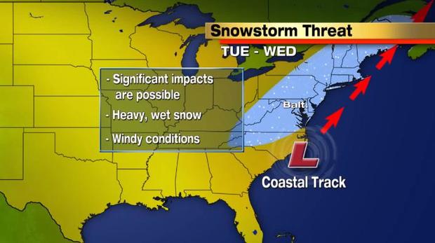
If the area of low pressure takes a coastal track, riding up along the Atlantic Seaboard, significant impacts are possible. The amount of snowfall we could see would mainly be determined by the timing of the precipitation.
If the bulk of the precipitation occurs at night Tuesday with temperatures below freezing in the absence of the strong March sun angle, we would be talking about several inches of snowfall. And that would mean that we could potentially have a mess on our hands by next Wednesday morning!
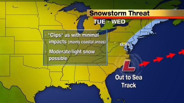
If the area of low pressure takes a more "out to sea" track, areas east of the I-95 corridor would be more likely to see minimal/moderate impacts. Light snow would be possible, but mainly for coastal areas.
This would be the more favorable scenario for many and would spare the mid-Atlantic of a significant, early spring snowstorm.
Future:
Even though many questions remain in regard to next week's possible snowstorm, one thing is pretty certain--we are going to be getting much colder! The jet stream will dip far enough south to unleash unusually cold air for late March right here in the mid-Atlantic. Highs on Monday will only reach into the upper 30s to near 40. That is nearly 10-20 degrees below average! So pull the winter coats out of the closet once again because you will need them as we kick off the work-week. Perhaps and winter coat in a spring color will make you feel better about the cold?
Other Local News: