One Last Blast Of Snow Passing Through Maryland
BALTIMORE (WJZ) -- Snow pushed in from southwest to northeast Tuesday morning and continues to overspread the region.
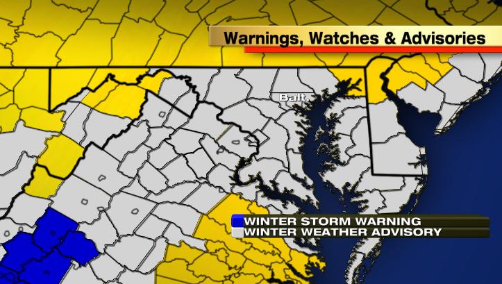
Meteorologist Chelsea Ingram breaks down the details.
For a look at live Doppler Radar, click here.
Winter weather advisories are in place and are not set to expire until Tuesday night.
Winter Weather Advisory through 8 p.m. Tuesday evening:
Washington, Carroll, Frederick, Howard, and Montgomery counties
Winter Weather Advisory through 12 a.m. Wednesday:
Baltimore City & Baltimore, Harford, Anne Arundel, Calvert, Charles, St. Mary's and Price George's Counties
Winter Weather Advisory through 2 a.m. Wednesday:
Maryland's Eastern Shore (except Cecil County)
DURING THE DAY:
Snowfall will continue to overspread the region through Tuesday afternoon. Some higher snowfall rates are possible, at times, as banding occurs within the storm. This is something that we will be watching very closely as higher snowfall rates would allow snowfall to more easily accumulate on paved surfaces, causing problems for the roadways.
TUESDAY NIGHT:
The storm's track has shifted slightly to the west, which means that we could see some wrap around snowfall later Tuesday evening and Tuesday for areas that are east of the I-95 corridor. For this reason, Winter Weather Advisories on the Eastern Shore will be the last to expire for the state of Maryland. Snow will begin to taper off near and around the I-95 corridor between 10 p.m. - 12 a.m. and then for the Eastern Shore between 12 a.m. - 2 a.m. Wednesday. A slight chance of a lingering flurry or light snow shower will be possible through Wednesday morning.
ACCUMULATIONS:
Accumulations will range anywhere from 1-3" with locally up to 4" possible in spots. If banding occurs Tuesday afternoon, we will likely see amounts closer to 4" in the areas affected. The bulk of the snowfall will accumulate on grassy and non-paved surfaces with the high March sun angle and road temperatures above freezing. Later Tuesday night, as the air temperature drops well below freezing, snow will be more likely to accumulate on just about any surface, so be sure to watch for slick spots on the road.
Maryland is certainly missing the worst of the storm. Parts of the New England coastline may see upwards of 1 foot of snowfall accumulation with winds gusting up to 55 mph! Atlantic Canada will get hit the worst as the storm is forecast to dump anywhere from 12-18″ in places like Nova Scotia!
AFTER THE STORM:
As the system pulls away, turning into a "powerhouse storm," strong northwest winds are forecast to develop into Wednesday. Winds will be sustained anywhere from 15-25 mph, gusting up to 40 mph before subsiding late Wednesday night. Highs on Wednesday are forecast to reach into the upper 30s, but when you factor in the wind chill, it will feel more like the single digits in the morning and then teens and 20s throughout the afternoon.
Other Local News: