Tropical Storm Fred Begins To Weaken
BALTIMORE (WJZ) — WJZ's First Warning Weather Team is tracking Tropical Storm Fred.
Update, Sept. 1, 11:10 a.m.: Tropical Storm Fred continues to quickly weaken this morning as the associated deep convection near the center has decreased in coverage and become less organized.
The center has also become exposed to the south of the remaining shower and thunderstorm activity.
Additional weakening is predicted during the next few days while Fred moves into a more hostile environment of increasing southwesterly shear, mid-level dry air, and marginal sea surface temperatures.
The tropical cyclone is expected to weaken to a tropical depression in 36 to 48 hours, and become a remnant low in 2 to 3 days, but this could occur sooner.
Fred is moving west-northwestward or 300 degrees at 9 kt. The tropical cyclone is expected to be steered west-northwestward to the south of a deep-layer ridge over the eastern Atlantic during the next couple of days.
The western portion of the ridge is forecast to weaken after 72 hours when a large mid- to upper-level trough begins to deepen over the central Atlantic.
This should cause the remnant low to turn northwestward late in the forecast period. The models that keep Fred stronger show the northwestward turn occurring much sooner than forecasted.
Update, Aug. 31, 10:11 p.m.: Fred likely peaked in intensity this morning. The environment ahead of Fred is expected to become increasingly hostile. As a result, steady weakening is predicted.
The center of Fred will pass near or over the northwestern Cape Verde Islands through early tonight. A turn toward the west-northwestward is expected on Tuesday. A west-northwestward heading should then continue during the remainder of the forecast period.
Update, Aug, 31, 10:42 a.m.: Tropical Storm Fred turned into a hurricane overnight and is churning off the coast of Africa moving closer to the Cape Verde Islands.
According to WJZ Meteorologist Chelsea Ingram, Hurricane Fred is the easternmost hurricane on record.
Flash flood warnings remain in effect for parts of Florida this morning as remnants of Tropical Storm Erika move through. Rip currents are possible all the way to the Carolinas.
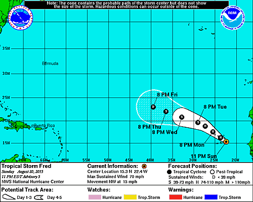
Update, Aug.30, 2015, 11:00 p.m.: Tropical Storm Fred is currently moving NW with winds at 15mph. The NWS says the system should remain over marginally warm sea surface temperatures with moderate vertical shear for the next day or so, and sounding data from Sal in the Cape Verde Islands indicate that the Saharan Air Layer is not very prominent ahead of Fred. Given these factors in the short term, the storm is likely to strengthen into a hurricane overnight.
A Hurricane Warning remains in effect for the Cape Verde Islands.

Update, Aug.30, 2015, 5:00 p.m.: Tropical Storm Fred formed in the Atlantic Ocean today and continues to strengthen on Sunday afternoon. The National Weather Service says additional strengthening is expected and it could become a hurricane late Sunday night or early Monday.
Fred's current location is 150 miles east south east of Praia in the Cape Verde Islands.
A Hurricane Warning has been issued for the Cape Verde Islands.


