Visitors Guide To Top Hikes In Gunpowder Falls State Park
By Sara Blumberg
Are you looking for a free way to exercise and enjoy nature at the same time? Then why not spend your day off enjoying the beauty of Gunpowder Falls State Park, a natural habitat consisting of 18,000 acres of preserved wildlife. The vast park, which extends from Hereford all the way down to Baltimore County, has more than 100 miles of trails varying in length and difficulty. Check out our guide of recommended hikes listed from easier to more difficult for you to try when visiting the area.
Gunpowder Falls State Park Headquarters
P.O. Box 480
2813 Jerusalem Road
Kingsville, Md. 21087
(410) 592-2897
Hours: Mon to Fri - 8:30 a.m. - 4:30 p.m.
Reviews, Directions & More Info
Lost Pond Trail- Central region- Baltimore County
Length: 4.3 miles
Cost: Free
Open: year round, closes at sunset
Directions: Take I-695 to Exit 32, MD-1 North (Belair Road). Go 5.5 miles look for parking lot straight ahead after crossing Gunpowder River.
Rate: Easy to moderate
Duration: 2 hours
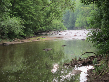
The Lost Pond Trail is a leisurely looped hike that starts on a flood plain along the Gunpowder River. From there visitors will hike upwards into the forest. On the way, look for an abandoned millpond that has become part of the forest. While hiking, you can also expect to cross through a variety of meandering streams cutting through the path. In addition, look out for traverse stone steps.
Wildlands Loops- Central region- Baltimore County
Length: 5.5 miles
Cost: Free
Open: year round, closes at sunset
Directions: Take I-695 to Exit 32, MD-1 North (Belair Road) Go 5.5 miles look for parking lot straight ahead after crossing Gunpowder River.
Rate: Easy to moderate
Duration: 3-4 miles
Another looped hike, the Wildlands Loop follows the Gunpowder River for 1.5 miles before continuing further into the woods. After crossing a few streams, visitors also view a waterfall that meanders downstream. Make sure to take note of the array of flowers that grow around the trail, including marigolds and periwinkles, which bloom generously in the spring months and attract curious hikers.
Gunpowder North Trail and South Trail- Hereford County
Length: 10 miles
Cost: Free
Open: all year, closes at sunset
Directions: From the Baltimore Beltway (I-695), take I-83 north 12.4 miles to Exit 27, Mt. Carmel Road. Turn right on Mt. Carmel Road. At traffic light, turn left on York Road. From there turn left on Bunker Hill Road and continue until you see the parking lot.
Rate: Moderate, due to hills on the trail
Duration: 3-4 hours
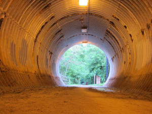
If you're craving beauty and shade at the same time, check out both the Gunpowder North Trail and Gunpowder South Trail in Harford County. While both trails are separated, visitors commonly will hike them together. As you walk upstream from the Gunpowder River, visitors get a chance to check out some natural sites including natural rock formations, varied flora and uncommon wildlife. It's not unusual to see a fox or wild turkey accompany you while hiking, so keep you eyes peeled for one. Insider's Tip: remember because of the rock formation, slight scrambling is involved during this particular hike.
One of the most interesting sites on the trails has to be Pretty Boy Dam. A vast structure, it was built in 1924 and completed nine years later. The dam was named for a farmer's horse, Prettyboy, who reportedly drowned near the structure. Hikers will reach the base of the dam and can climb to the top of it, to access great views of the park.
Torrey C. Brown Trail- Hereford Region- Baltimore County
Length: 21 miles
Cost: free
Open: All year, closes at sunset
Directions: From I-83N, take exit 27 and turn right on Mount Carmel Road. Turn right on York Road and make a quick left onto Monkton Road. Follow it until it crosses the Torrey C. Brown Trail. The Monkton Train Station building will be on your left. There is limited parking.
Rate: Moderate to difficult due to length
Duration: 4-5 hours
Originally known as the Northern Central Railroad, the Torrey C. Brown trail consisted of 21 miles of abandoned railroad track. For 130 years the trail served as an active railroad, travelling well into Pennsylvania. After the company closed the route down, the tracks were abandoned. In 1984, a group of volunteers came together in conjunction with the Maryland Department of Natural Resources, and converted it into a trail. Everyday hundreds of people flock to the nature reserve to enjoy walking, running and biking. From marathon runners to horseback riders, the trail attracts a variety of nature enthusiasts.
The trail consists of mainly crushed stone path. While flat, the lush forest provides for beautiful views. Hikers should take a rest stop at the Monkton Train Station to learn more about the history of the old railroad.
For more information on all hikes, make sure to check out the Gunpowder Falls State Park official website. Don't forget we have hiking hot spots near the Baltimore area. You can check them out here.
Sara Blumberg is a freelance blogger living in Baltimore City. Visit her blog at sarabydesign.wordpress.com.