Time To Prepare: More Snow On The Way For Thursday Into Friday
BALTIMORE (WJZ) -- We are setting our sights on a Thursday p.m. to Friday a.m. storm system that will follow the same pattern as earlier this week, bringing more snow to the region.
A Winter Storm Watch will go into effect Thursday at 6 p.m. and remain in effect until 7 a.m. Friday. The "Watch" will be elevated to a "Warning" as we get within about 12 hours of the event.
First, there will be a weak cold front moving across the mid-Atlantic Wednesday afternoon through Thursday morning.
It will reinforce the cold air in place. The area of low pressure bringing the moisture will approach from the southwest.
Timing brings the precipitation in as temperatures drop overnight into the mid 20's. Temps will support an all-snow event, which means we won't have to deal with any ice.
It's a bit unusual to have back-to-back winter storms where the higher snow amounts are south and the lower amounts north of the metro area.
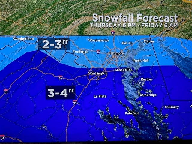
We are currently looking at 2-3 inches across the top half of the state, with 3-4 inches expected across the lower half.
This will play out during WJZ News at 11 p.m. on Thursday and remain active and visual through the Friday WJZ morning show.
We will watch the snow taper near sunrise (about 7 a.m.)
The Friday morning commute will likely be an absolute mess and we can almost guarantee school closures statewide – again.