Maryland Weather: Nor'Easter Snowstorm Arrives
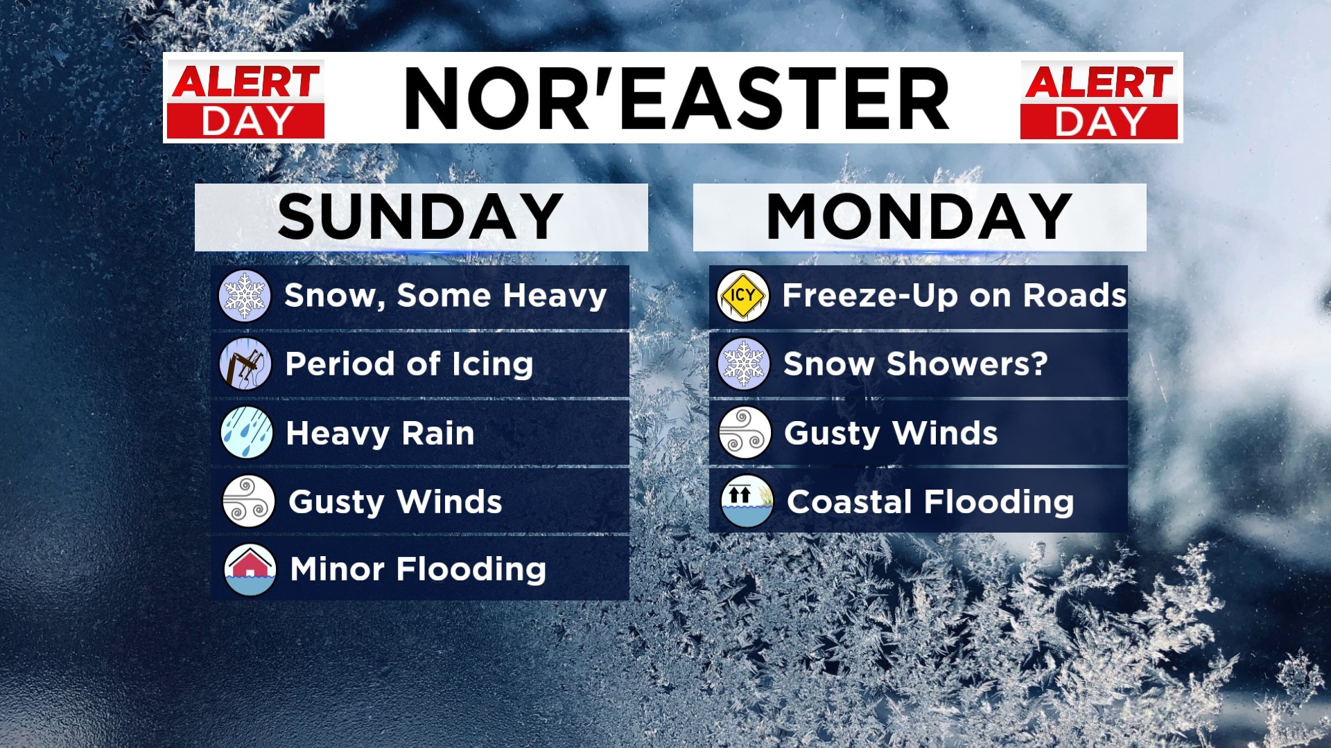
BALTIMORE (WJZ) -- The Nor'Easter your First Alert Weather Team has been tracking is now on our doorstep! We've declared Alert Days for both today and Monday because of the wide ranging impacts from this system.
A Winter Storm Warning is in effect for Allegany, Frederick, Garrett and Washington Counties from 1 p.m. Sunday to 7 a.m. Monday.
A Winter Weather Advisory is in effect for Baltimore City, Baltimore, Harford, Cecil, Carroll, Howard, Anne Arundel, Montgomery, Prince George's & Charles Counties from 1 PM today to 1 AM Monday.
There is a frigid air mass in place as we wait for your precipitation to arrive. Snow will begin around 1 p.m. and continue into the evening. Around
We're expecting the I-95 corridor to see a transition to a wintry mix between 6-8 PM. That could cause icing on the roads. That sleet and freezing rain will then change over to a cold rain between 8-10 PM. Some of the rain could be heavy and there is the potential for minor flooding.
WJZ's Marty Bass said rain will be dominant in the metro area as temperatures rise overnight.
This slushy mess will make travel difficult so if you don't need to be on the roads this afternoon through tomorrow morning, we recommend not being.
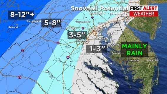
Forecasted snowfall totals are significantly higher in Western Maryland because of an all snow event that may exceed 24 hours.
Gusty winds will also be an issue as this system tracks through. Expect winds between 30-40 MPH. This will create blizzard like conditions in the mountains.
Coastal Flooding is also possible starting late this afternoon through Monday. A Coastal Flood Watch is in effect for Baltimore City, Baltimore, Harford and Cecil Counties from late tonight into Monday night. One to two feet of inundation above ground level in low lying areas is possible.
Coastal Flood Warnings are in effect for Anne Arundel, St. Mary's, Dorchester, Wicomico and Somerset Counties.
Some brief periods of snow are possible on Monday. Temperatures will top out near 40° but expect it to feel like the 20s thanks to the gusty winds.
Calm weather arrives Tuesday but we're tracking the possibility for another winter storm late Friday into Monday. We may be issuing alert days for that event but for now, we will just give you a heads up as we keep an eye on the models.