Tracking Hurricane Joaquin: More Rain, Flooding Forecast Along Soggy East Coast
BALTIMORE (WJZ)--The First Warning Weather team continues to tracking your weekend weather and any possible effects from Hurricane Joaquin.
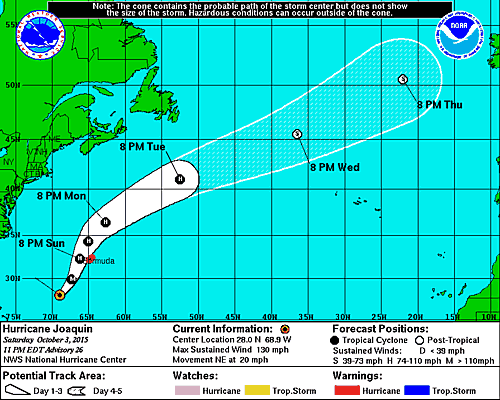
Updated, Oct 2, 11:00 p.m.: Hurricane Joaquin is moving NE at 20 mph with max sustained wins 130 mph. While the cloud pattern has deteriorated a little this evening, reports from an Air Force Reserve Hurricane Hunter aircraft indicate that Joaquin is still a Category 4 hurricane.
Tropical storm conditions are first expected to reach Bermuda by Sunday morning, with hurricane conditions expected by Sunday afternoon.Outer rain bands of Joaquin will begin to affect Bermuda by early Sunday, and Joaquin is expected to produce 3 to 5 inches of rainfall over Bermuda through Monday.
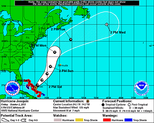
Update, Oct 2, 4:30 p.m.: Hurricane Joaquin is currently moving NE at 18 mph with sustained winds at 155 mph.
On the forecast track, the eye of Joaquin will pass west of Bermuda on Sunday. However, a small deviation to the east of the forecast track would bring the core of the hurricane and stronger winds closer to Bermuda.
Tropical storm conditions are first expected to reach Bermuda by Sunday morning, with hurricane conditions possible by Sunday afternoon.
Update, Oct 3, 3:00 p.m.: The U.S. National Hurricane Center in Miami says Hurricane Joaquin has strengthened again into a Category 4 storm.
The hurricane had dropped to a Category 3 on Friday but was upgraded early Saturday afternoon with maximum sustained winds near 155 mph (250 mph), with higher gusts. A gradual weakening was expected later in the day.
The center said swells generated by Joaquin will continue to affect portions of the Bahamas over the next few days.
A tropical storm warning and a hurricane watch were issued for Bermuda. Tropical storm conditions are expected to reach Bermuda by Sunday morning, with hurricane conditions possible later in the day.
Updated, Oct. 2, 11:00 p.m.: Hurricane Joaquin is currently moving NE at 10 mph, away from the Bahamas as conditions gradually begin to subside.
The Director of the Meteorological Service of the Bahamas reported to NHC that there was considerable damage on some islands of the central Bahamas. Joaquin could fluctuate in intensity during the next 12 to 24 hours, but given that the shear is expected to increase, the NHC forecast calls for very gradual weakening.
The Government of the Bahamas has discontinued all watches and warnings for the northwestern Bahamas. The Bermuda Weather Service has issued a Tropical Storm Warning and a Hurricane Watch for Bermuda.
Update, Oct. 2, 7:30 p.m.: Hurricane Joaquin is currently moving N at 7 mph. Hurricane conditions over portions of the Bahamas should continue for several more hours. Swells from a hurricane moving even far offshore of the U.S. east coast can still cause life-threatening surf and rip-current conditions.
Update, Oct. 2 3:19 p.m.: Gov. Larry Hogan is hoping to focus resources where needed in Maryland so with recommendations from MEMA has rescinded the state of emergency in eight Maryland counties.
Garrett, Allegany, Washington, Frederick, Carroll, Montgomery, Howard, and Prince George's are no longer under a state of emergency.
Update, Oct. 2, 2:10 p.m.: Ocean City has officially closed it's beaches are surf and winds grow stronger due to nor'easter.
We're going to received some beach erosion along the dune front. It is not a place to be. So the beach is officially closed until further notice." Rick Meehan, mayor of Ocean City said.
Wow. #OceanCity #WJZ @cbsbaltimore pic.twitter.com/kCitmKj3g8
— Rick Ritter (@RickRitterWJZ) October 2, 2015
//platform.twitter.com/widgets.js
Update, Oct. 2, 1:15 p.m.: Maryland business owners and residents in Fells Point, Annapolis and other low-lying areas of Maryland are preparing for potential flooding.
The city of Baltimore is passing out sandbags and crews are in place in case trees go down and power goes out due to the weather.
Update, Oct, 2, 12:21 p.m.: Meteorologist Tim Williams reports that newer models show Joaquin's path moving away from the coastline, we're still seeing effects from heavy rain in the region.
Still a category 4 storm, Joaquin has 130 mph winds.
However from what we can see from the "cone of uncertainty" is each update has been taking it farther and farther east and away from Maryland.
Update, Oct. 2: 8:23 a.m.: Although new models show Hurricane Joaquin moving out to sea, the storm could still bring strong winds and more rain to Maryland and other East Coast states already drenched from the Nor'easter.
Two storm-related deaths have already occurred in the Carolinas, where heavy rain has fallen for days.
Governors declared states of emergency in at least five states as forecasters warned of flash floods from historic Charleston, South Carolina, to Washington, D.C. -- regardless of whether Joaquin comes ashore or tracks farther out to sea.
"I know we like to focus on the hurricane," said David Novak, director of the National Oceanic and Atmospheric Administration's Weather Prediction Center in College Park, Maryland. But whatever track Joaquin takes, "we're becoming increasingly confident and concerned about the heavy rainfall."
Streets and homes can still get walloped with rain and flooding associated with the hurricane even if it is 1,000 miles away, forecasters said. And because Joaquin can keep funneling tropical moisture into storm No. 1 from afar, even an out-to-sea Joaquin can worsen flooding.
The latest forecast track for the hurricane early Friday showed it was expected to stay off-shore as it moved northward over the coming days.
But the certainty of additional damaging rains and floods in coming days prompted governors to declare states of emergency in Maryland, New Jersey, North Carolina, South Carolina, and Virginia.
Update, Oct. 2, 12:30 a.m.: Hurricane Joaquin is currently moving W at 3 mph. The forecast models continue to indicate a track farther away from the United States east coast and the threat of direct impacts from Joaquin in the Carolinas and mid-Atlantic states appears to be decreasing.
Joaquin's slow motion means that extremely dangerous conditions will continue over portions of the warning areas in the Bahamas well into Friday.
Even if Joaquin moves out to sea, strong onshore winds associated with a frontal system will create minor to moderate coastal flooding along the coasts of the mid-Atlantic and northeastern states through the weekend.

Update, Oct.1, 8:00 p.m.: Hurricane Joaquin is moving through the Central Bahamas at this hour. Hurricane conditions to continue over the Central Bahamas tonight.
Joaquin's slow motion means that extremely dangerous conditions will continue over portions of the warning areas in the Bahamas well into Friday.
Even if Joaquin moves out to sea, strong onshore winds associated with a frontal system will create minor to moderate coastal flooding along the coasts of the mid-Atlantic and northeastern states through the weekend.

Update, Oct.1, 5:00 p.m.: Hurricane Joaquin is currently moving SW at 6 mph with sustained winds at 130 mph. Joaquin is expected to intensify a little more during the next 12 hours or so as it remains over very warm waters and in an environment of decreasing vertical shear. After that time, there could be some fluctuations in intensity due to eyewall replacement cycles.
A Hurricane Warning is in effect for: Central Bahamas, Northwestern Bahamas including the Abacos, Berry Islands, Eleuthera, Grand Bahama Island, and New Providence, The Acklins, Crooked Island, and Mayaguana in the southeastern Bahamas
Update, Oct. 1, 3:16 p.m.: Gov. Larry Hogan declares a state of emergency in Maryland; asks Marylanders to prepare for the storm.
Current models showing the storm headed offshore, officials said, but its path remains uncertain.
"We're hoping for the best, but preparing for the worst," Hogan said.
Update, Oct. 1, 2:02 p.m.: Joaquin is now a Category 4 storm.
Around the Chesapeake Bay boats are being pulled in form the water as residents brace for Joaquin.
Rick Ritter will have updates from in Ocean City tonight on WJZ.
Ocean City, MD. @cbsbaltimore pic.twitter.com/u2FWPzIVEm
— Rick Ritter (@RickRitterWJZ) October 1, 2015
Update, Oct. 1, 12:58 p.m.: Meteorologist Tim Williams reports that Joaquin jumped two levels and went from a category 1 hurricane to a category 3 hurricane in a day.
Williams said the storm is expected to intensify into category 4 storm before it heads our way.
The latest model reports the storm will be headed offshore but it could still effect Ocean City and the Eastern Shore. However, the course of the storm remains uncertain and it could have major impacts in our area.
Update, Oct. 1, 7:42 a.m. Some minor damage was reported by Bahamas officials late Wednesday, and islanders rushed to prepare for storm surges and heavy rain from the approaching Joaquin.
Authorities said the center was likely to pass near or over several islands during the night and Thursday.
Joaquin was a Category 3 storm with maximum sustained winds of 120 mph (195 kph) and hurricane strength winds extending 35 miles (55 kilometers) from the eye early Thursday, the U.S. National
Hurricane Center in Miami said. As of 5 a.m. EDT, the center of the storm was about 20 miles (35 kilometers) north of Samana Cays, Bahamas, and moving west-southwest at 5 mph (7 kph).
The storm was predicted to turn to the north and northwest toward the United States late Thursday or Friday, but forecasters were still gathering data trying to determine how it might affect the U.S.
"We've got Air Force reconnaissance planes continuously giving us data from inside the hurricane this morning, and we're going to be throwing a lot more aircraft resources at this problem over the next few days because it still is not certain whether or not Joaquin will directly impact the U.S. East Coast or stay out to sea," said Rick Knabb, director of the National Hurricane Center.
On Eleuthera, a narrow strip to the north of Cat Island, people removed stray coconuts and other debris from their yards and put up storm shutters in blustery winds, said Chris Gosling, who runs a volunteer ambulance service on the island. Islanders have learned from past storms not to take chances.
"People don't panic too much. There's nothing you can do about it. If it comes, it comes, and you do what you can," said Gosling, who has lived on Eleuthera for 27 years. "If the forecast is right we will get some wind and rain and it will go back out to sea."
A hurricane warning was posted for Eleuthera as well as San Salvador, Cat Island and Rum Cay, with the threat of storm surges, coastal flooding and 5-10 inches (13-25 centimeters) of rain, said Geoffrey Greene, a senior forecaster with the Bahamas Meteorology Department.
"We would be very concerned about them," Greene said.
Stephen Russell, director of the country's National Emergency Management Agency, said Wednesday night that storm surges washed out a portion of the main road on San Salvador and some people in low-lying areas of Mayaguana island were urged to evacuate their homes.
Those islands have relatively small populations, fewer than 1,000 on San Salvador, but they are vulnerable in a storm since most of the people live along the shoreline in modest homes.
A warning also was issued for some more populous islands in the northwestern Bahamas, including Grand Bahama and New Providence, where the capital of Nassau is.
The U.S. National Hurricane Center's long-term forecast showed the storm could near the U.S. East Coast along North Carolina and Virginia on Sunday.
"Residents of the Carolinas north should be paying attention and monitoring the storm. There's no question," said Eric Blake, a hurricane specialist with the center. "If your hurricane plans got a little dusty because of the light hurricane season, now is a good time to update them."
Update: Sept. 30, 10:30 p.m. :
A strengthening Hurricane Joaquin approached the central islands of the Bahamas on Wednesday evening, following a projected track that would take it near the U.S. East Coast by the weekend.
Maximum sustained winds reached 105 mph (165 kph) and extended 35 miles (55 kilometers) from the center of the storm over the Atlantic Ocean, according to the U.S. National Hurricane Center in Miami, which predicted Joaquin would develop into a major hurricane in the coming days.
Authorities in the Bahamas prepared for a brush with the storm, with the center expected to pass near or over several islands during the night and Thursday.
A turn to the north and northwest toward the United States was expected late Thursday or Friday, but forecasters were still gathering data trying to determine how it might affect the U.S.
"We've got Air Force reconnaissance planes continuously giving us data from inside the hurricane this morning, and we're going to be throwing a lot more aircraft resources at this problem over the next few days because it still is not certain whether or not Joaquin will directly impact the U.S. East Coast or stay out to sea," said Rick Knabb, director of the National Hurricane Center.
A hurricane warning was posted for the islands of San Salvador, Cat Island, Eleuthera and Rum Cay, with the threat of storm surges, coastal flooding and 5-10 inches (13-25 centimeters) of rain, said Geoffrey Greene, a senior forecaster with the Bahamas Meteorology Department.
"We would be very concerned about them," Greene said.
Stephen Russell, director of the country's National Emergency Management Agency, said the approach of the storm brought storm surges that washed out a portion of the main road in San Salvador and some people in low-lying areas on the island of Mayaguana were urged to evacuate their homes.
Those islands have relatively small populations, fewer than 1,000 on San Salvador, but they are vulnerable in a storm since most of the people live along the shoreline in modest homes.
A warning also was issued for some more populous islands in the northwestern Bahamas, including Grand Bahama and New Providence, where the capital of Nassau is.
On Eleuthera, a narrow strip to the north of Cat Island, people removed stray coconuts and other debris from their yards and put up storm shutters in blustery winds, said Chris Gosling, who runs a volunteer ambulance service on the island. Islanders have learned from past storms not to take chances.
"People don't panic too much. There's nothing you can do about it. If it comes, it comes, and you do what you can," said Gosling, who has lived on Eleuthera for 27 years. "If the forecast is right we will get some wind and rain and it will go back out to sea."
The U.S. National Hurricane Center's long-term forecast showed the storm could near the U.S. East Coast above North Carolina on Sunday.
"Residents of the Carolinas north should be paying attention and monitoring the storm. There's no question," said Eric Blake, a hurricane specialist with the center. "If your hurricane plans got a little dusty because of the light hurricane season, now is a good time to update them."
The center of the storm Wednesday evening was about 95 miles (150 kilometers) east of the central Bahamas and moving toward the southwest at 7 mph (11 kph).
Update: Sept. 30, 9:15 p.m. :
Bob Turk notes that Joaquin may land in the Carolinas instead of our area.
"I just looked at about ten different hurricane model tracks, and an interesting shift to the west has been noted by all these models. Hurricane Joaquin now a cat 2 storm with winds up to 105mph is approaching the central Bahamas this evening and hurricane warnings are in place. These updated models have the storm now more focused on the Carolinas rather than the Chesapeake region, this may change,but it is interesting that this shift has occurred tonight. Future tracks will change, I'm sure, as we get closer to the weekend. In the meanwhile a totally different low pressure is going to develop along a stalled cold front now east of us, and develop another major rain event on Friday, with the potential for 1 to 3 inches of additional rains! More local flooding will be possible at that time. and this is long before any impacts here from the hurricane. Please stay tuned as these models and forecasts will be constantly updated," he said.
Update: Sept. 30, 8 p.m. :
A strengthening Hurricane Joaquin approached the central islands of the Bahamas on Wednesday evening, following a projected track that would take it near the U.S. East Coast by the weekend.
Maximum sustained winds reached 105 mph (165 kph) and extended 35 miles (55 kilometers) from the center of the storm over the Atlantic Ocean, according to the U.S. National Hurricane Center in Miami, which predicted Joaquin would develop into a major hurricane in the coming days.
Authorities in the Bahamas prepared for a brush with the storm, with the center expected to pass near or over several islands during the night and Thursday.
A turn to the north toward the United States was expected by Thursday night or Friday, but forecasters were still gathering data trying to determine how it might affect the U.S.
"We've got Air Force reconnaissance planes continuously giving us data from inside the hurricane this morning, and we're going to be throwing a lot more aircraft resources at this problem over the next few days because it still is not certain whether or not Joaquin will directly impact the U.S. East Coast or stay out to sea," said Rick Knabb, director of the National Hurricane Center.
A hurricane warning was posted for the islands of San Salvador, Cat Island, Eleuthera and Rum Cay, with the threat of storm surges, coastal flooding and 5-10 inches (13-25 centimeters) of rain, said Geoffrey Greene, a senior forecaster with the Bahamas Meteorology Department.
"We would be very concerned about them," Greene said.
Those islands have relatively small populations, fewer than 1,000 on San Salvador, but they are vulnerable in a storm since most of the people live along the shoreline in modest homes.
A warning also was issued for some more populous islands in the northwestern Bahamas, including Grand Bahama and New Providence, where the capital of Nassau is.
On Eleuthera, a narrow strip to the north of Cat Island, people removed stray coconuts and other debris from their yards and put up storm shutters in blustery winds, said Chris Gosling, who runs a volunteer ambulance service on the island. Islanders have learned from past storms not to take chances.
"People don't panic too much. There's nothing you can do about it. If it comes, it comes, and you do what you can," said Gosling, who has lived on Eleuthera for 27 years. "If the forecast is right we will get some wind and rain and it will go back out to sea."
The U.S. National Hurricane Center's long-term forecast showed the storm could near the U.S. East Coast above North Carolina on Sunday.
"Residents of the Carolinas north should be paying attention and monitoring the storm. There's no question," said Eric Blake, a hurricane specialist with the center. "If your hurricane plans got a little dusty because of the light hurricane season, now is a good time to update them."
The center of the storm Wednesday evening was about 95 miles (150 kilometers) east of the central Bahamas and moving toward the southwest at 7 mph (11 kph).
Update: Sept. 30, 5 p.m.
People on the islands of the eastern Bahamas are getting ready for Hurricane Joaquin, removing stray coconuts and other debris from their yards and putting up storm shutters in blustery winds.
At 5 p.m. Wednesday, Joaquin was about 175 miles (282 kilometers) east of the central Bahamas and has winds of about 85 mph (137 kph).
Chris Gosling runs a volunteer ambulance service on Eleuthera, a narrow strip to the north of Cat Island. He says people aren't panicking too much. Islanders are preparing for heavy rains, strong winds and flooding
Update: Sept. 30, 4 p.m.: Steady rain is drenching much of the East Coast, flooding roads, closing schools and forcing some people from their homes. And forecasters say the worst is yet to come.
The storms may soon be joined by Hurricane Joaquin in a powerful weather system that may linger for days and dump as much as 10 inches in some places through early next week.
Bruce Terry is lead forecaster for the government's Weather Prediction Center. He says heavy rains are likely from the Carolinas to New England.
Flooding has already been a problem from storms in the last several days. In southwest Virginia, schools closed early Tuesday in several counties because of flooded roads. About 100 people had to be helped from low-lying homes in Salem, Virginia.
UPDATE: Wednesday, 1:00 p.m.: The NWS says Joaquin has continued to strengthen overnight and satellite imagery shows what might be an "eye" trying to form. Joaquin continues to strengthen as it moves Southwestward toward the Central Bahamas.
The storm currently has maximum sustained winds at 80 mph.
A Hurricane Warning is in effect for: Central Bahamas including Cat Island, the Exumas, Long Island, Rum Cay, and San Salvador.
Tim Williams has more on how Joaquin could affect Maryland weather this week.
WJZ's First Warning Weather Team will be following the path of Joaquin.
MORE: Current Conditions | Download The App
Update: Sept. 30, 8:00 a.m.: Marty Bass reports that Joaquin could make landfall somewhere between the Carolinas and the Mid-Atlantic later in the week.
Bass said Joaquin would probably go from a category 1 hurricane to a category 2 hurricane then back to a 1.
However, some European models are showing the storm moving back into the ocean.
Meanwhile in the Pacific, Marty has weakened to a tropical depression as it moves away from Mexico's coast.
Marty's maximum sustained winds have decreased to near 35 mph (55 kph) and it's expected to weaken to a remnant low later Wednesday or on Thursday. The depression is centered about 115 miles (185 kilometers) south-southwest of Zihuatanejo, Mexico.